


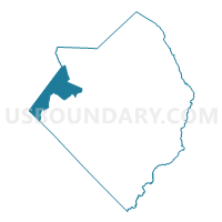
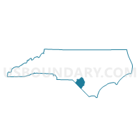
Voting District 19, Robeson County, North Carolina
About
Outline

Summary
| Unique Area Identifier | 641254 |
| Name | Voting District 19 |
| County | Robeson County |
| State | North Carolina |
| Area (square miles) | 44.47 |
| Land Area (square miles) | 44.15 |
| Water Area (square miles) | 0.31 |
| % of Land Area | 99.29 |
| % of Water Area | 0.71 |
| Latitude of the Internal Point | 34.69065090 |
| Longtitude of the Internal Point | -79.35987760 |
Maps

Graphs
Select a template below for downloading or customizing gragh for Voting District 19, Robeson County, North Carolina


Neighbors
Neighoring Voting District (by Name) Neighboring Voting District on the Map
- Voting District 01, Robeson County, NC
- Voting District 2, Scotland County, NC
- Voting District 23, Robeson County, NC
- Voting District 34, Robeson County, NC
- Voting District 35, Robeson County, NC
- Voting District 39, Robeson County, NC
- Voting District 5, Scotland County, NC
- Voting District 6, Scotland County, NC
- Carolina Voting District, Dillon County, SC
- Clio Voting District, Marlboro County, SC
Top 10 Neighboring County Subdivision (by Population) Neighboring County Subdivision on the Map
- Stewartsville township, Scotland County, NC (20,184)
- Pembroke township, Robeson County, NC (13,732)
- Smiths township, Robeson County, NC (6,030)
- Maxton township, Robeson County, NC (5,880)
- McColl CCD, Marlboro County, SC (4,732)
- Little Rock CCD, Dillon County, SC (3,467)
- Union township, Robeson County, NC (3,053)
- Alfordsville township, Robeson County, NC (2,146)
Top 10 Neighboring Place (by Population) Neighboring Place on the Map
Top 10 Neighboring Unified School District (by Population) Neighboring Unified School District on the Map
- Robeson County Schools, NC (134,168)
- Scotland County Schools, NC (36,157)
- Marlboro County School District, SC (28,933)
- Dillon School District 2, SC (18,998)
Top 10 Neighboring State Legislative District Lower Chamber (by Population) Neighboring State Legislative District Lower Chamber on the Map
- State House District 46, NC (77,493)
- State House District 47, NC (73,340)
- State House District 48, NC (66,444)
- State House District 55, SC (34,048)
- State House District 54, SC (32,159)
Top 10 Neighboring State Legislative District Upper Chamber (by Population) Neighboring State Legislative District Upper Chamber on the Map
- State Senate District 13, NC (181,120)
- State Senate District 25, NC (170,329)
- State Senate District 28, SC (97,383)
Top 10 Neighboring 111th Congressional District (by Population) Neighboring 111th Congressional District on the Map
- Congressional District 5, SC (767,773)
- Congressional District 7, NC (742,938)
- Congressional District 8, NC (709,449)
Top 10 Neighboring Census Tract (by Population) Neighboring Census Tract on the Map
- Census Tract 9604.01, Robeson County, NC (7,157)
- Census Tract 9618.01, Robeson County, NC (5,086)
- Census Tract 9604, Marlboro County, SC (4,732)
- Census Tract 104, Scotland County, NC (3,906)
- Census Tract 9620.01, Robeson County, NC (3,709)
- Census Tract 9701, Dillon County, SC (3,467)
- Census Tract 9605.01, Robeson County, NC (3,413)
- Census Tract 9620.02, Robeson County, NC (3,220)